Applications of Digital Technologies and AI in Assessment of Tunneling Induced Settlement Impacts
May 5, 2026
Digital transformation is redefining how engineers assess and manage tunneling-induced settlement in dense urban environments. Traditional, fragmented workflows—spanning geotechnical modeling, structural evaluation, and documentation—are being replaced by integrated digital ecosystems that combine GIS, AI, and computer vision. This article explores how these technologies enable faster, data-driven, and more transparent assessment of settlement impacts, marking a step-change in risk management for urban tunneling projects.
- Limitations of Conventional Practice
Urban tunneling projects routinely pass beneath a large number (often hundreds) of structures whose tolerance for ground movement varies substantially. Predicting the settlement trough generated by a chosen tunneling method (using tunnel boring machine (TBM), or conventional) and translating that trough into a structure-specific damage assessment has traditionally relied on a sequence of loosely connected tasks: gathering as-built records, digitizing building footprints, estimating greenfield ground deformations using Gaussian empirical methods (Peck, 1969) or finite-element models, and then applying frameworks such as Burland and Wroth (1975) to classify potential damage. Each step typically lives in a different workflow environment, is managed by a unique team, and produces outputs in a various format.
The practical consequences of this work fragmentation are that building condition surveys arrive as scanned PDFs; geotechnical profiles reside in proprietary borehole database software; settlement predictions are often exported as spreadsheets, and structural assessments are documented as standalone reports. The resulting partial outcomes greatly depend on manual cross-referencing; also, updates to various components are generally slow when the alignment changes occur. In addition, the process offers limited transparency of magnitude of impacts expected to project stakeholders who increasingly demand real-time, visual evidence of how construction risks are addressed for various alignment options and what would be the resulting cost, schedule, right-of-way and other impacts on a project.
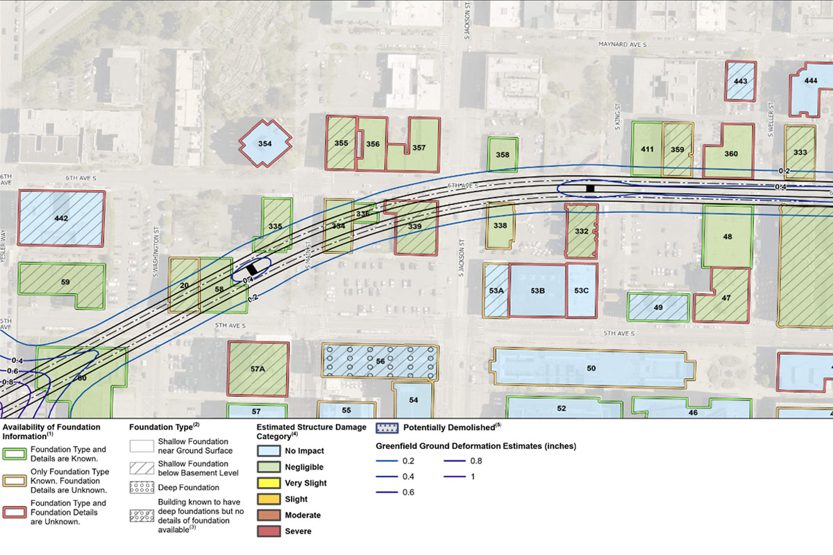
Furthermore, conventional practice treats building footprints as static inputs. An engineer typically obtains parcel boundary data from municipal GIS records, overlays it on the settlement contour map, and manually identifies which structures fall within the zone of influence. Extracting the actual vertex coordinates of a building’s structural footprint that is needed to compute differential settlement, angular distortion, and horizontal strain across each facade remains a labor-intensive process involving manual digitization from aerial photographs or as-built drawings. On a project with several hundred structures in the zone of influence, this alone can consume weeks of engineering effort and is prone to human error. - New Digital Process – Integrating GIS, AI, and Computer Vision
The emerging digital framework replaces this piecemeal approach with an integrated GIS-based common data environment (CDE) that fuses geotechnical data, tunnel alignment geometry, settlement predictions, utility networks, and building condition information into a single georeferenced platform. As described in recent work on GIS interoperability for tunneling (Gangrade and Savage, 2025), tools such as Esri’s ArcGIS, combined with data transformation engines like FME (Feature Manipulation Engine), enable the ingestion of BIM models (Revit, Civil 3D) directly into a web-GIS environment. The result is an interactive map in which an engineer can click on a borehole and view the stratigraphic log, toggle settlement contour overlays, and inspect the assessed damage category of every structure along the alignment, all within a single browser window.
The more transformative development, however, lies in the use of computer vision and deep learning to automate the extraction of building polygon vertex coordinates from remote sensing imagery. Within this digital framework, a GIS based learning algorithm detects the building corners from satellite imagery and generates the linework for polygons that end up as inputs for building outline limits.
In the tunneling settlement context, the process works as follows. High-resolution satellite or aerial imagery of the corridor is processed through a trained vertex-extraction model to produce georeferenced polygonal footprints with explicit vertex coordinates. These polygons are ingested into the GIS-CDE, where a Python-based processing module decomposes each polygon edge into facade segments aligned with the tunnel axis. The greenfield settlement trough whether derived from empirical Gaussian curves, numerical modeling, or real-time AI predictions is then sampled at each vertex to compute differential settlement and horizontal strain across each facade. The Burland damage category for each structure is calculated automatically and written back to the GIS as a metadata attribute, enabling instant color-coded visualization of outputs across the entire alignment. - Advantages of Informed Decision-Making
The integration of these technologies fundamentally changes how tunneling risk is managed. First, the feedback loop tightens considerably. When an alignment shift is proposed, say, a 5-ft horizontal adjustment to avoid critical utility, the settlement predictions and building damage classifications can be regenerated within hours rather than weeks, because the building geometries, ground model, and analysis engine are already linked within the CDE. This enables true parametric design exploration, where multiple alignment alternatives are evaluated against a consistent, quantified risk metric.
Second, real-time settlement monitoring data from instrumentation arrays can be fed into the same platform. Machine learning models trained on earlier sections of the drive can update settlement predictions for upcoming reaches, and the building damage classifications update accordingly. This moves the industry from a static, pre-construction risk register toward a living, dynamic risk model that evolves as construction proceeds and as-built alignment is materialized, an aspiration that has been discussed for years but is now technically achievable.
Third, the automated extraction of building vertex coordinates removes a major bottleneck in the damage assessment process and, critically, reduces the subjectivity inherent in manual digitization. Fourth, the visual clarity of a single GIS dashboard showing settlement contours, damage categories, instrumentation readings, and building metadata provides an unprecedented communication tool for project stakeholders. Owners, regulators, insurers, and community groups can interact with the data directly rather than relying on static PDF reports. This transparency builds confidence in the risk management process and facilitates faster resolution of disputes when actual ground movements deviate from predictions. - Leveraging Digital Tools
For engineering firms, the investment in these digital capabilities translates into tangible competitive advantages. The efficiency gains are substantial: automated building footprint extraction and integrated damage assessment can reduce the engineering hours devoted to settlement impact analysis by an order of magnitude on large urban projects. This is not a marginal improvement, it is the qualitative difference between a team of multiple engineers spending months on manual digitization and cross-referencing, and a streamlined workflow that delivers equivalent or superior results in a fraction of the time.
Firms that build proprietary GIS-CDE platforms also create institutional knowledge assets that compound over successive projects. The ground models, settlement databases, and trained AI models from one tunnel project become baseline datasets for the next, enabling progressively more accurate predictions and faster project mobilization. In an industry that is increasingly specifying digital delivery requirements and CDE as contractual obligations, firms with these capabilities have significant advantages for major transit and infrastructure programs.
Most importantly, the integration of AI-driven settlement prediction with automated building footprint extraction and GIS-based visualization positions engineering firms to offer a fundamentally different service model. This represents the next frontier in tunneling engineering practice that pioneers qualitatively better standards of care for complex urban underground infrastructure projects.
Rajat Gangrade, Ph.D., P.E., is Technical Advisor – Geotechnical and Tunneling for HNTB Corp.
Comments are closed here.